
WoFS Ensemble Configuration
Up through and including 2021, WoFS has used the Advanced Weather Research and Forecast (WRF-ARW core) dynamic solver developed in collaboration with NCAR and Global Systems Laboratory (GSL). The WRF code used by WoFS in 2021 is based on the code used by the High-Resolution Rapid Refresh (HRRR) model in 2020, and is modified to meet the requirements for accurate short-term (0–6 hour) forecasts. One modification is the use of NSSL double moment cloud microphysics.
WoFS uses data assimilation tools developed by the WoF research team for ensemble Kalman Filter assimilation of high-resolution Multi-Radar, Multi-Sensor radar reflectivity and radial velocity data and satellite data. The 2021 configuration of WoFS consists of a 36-member ensemble with a regional domain (900 x 900 km) centered around the area of expected high impact weather for a particular day. WoFS operates at a convection-allowing 3-km horizontal resolution with 15-min data assimilation intervals, and assimilates available WSR-88D radar data, Geostationary Operational Environmental Satellite (GOES)-16 and 17 satellite, and conventional observations. High resolution radar and satellite-derived observations are resampled from their native resolution to a 5-km grid prior to assimilation.
Initial and lateral boundary conditions (ICs/LBCs) are generated from an experimental HRRR Ensemble analysis and forecast developed by collaborators from GSL. Each of the 36 WoFS ensemble members has a unique combination of IC/LBCs, boundary layer physics scheme, and radiation scheme, which helps to maintain ensemble spread through the cycling period. Outlier thresholds are applied to reduce the impact of potential non-representative observations to the system.
Forecasts are generated using the first 18 members, at selected times, to create probabilistic high impact weather forecasts, which provide a measure of uncertainty not available from a single deterministic forecast. The experimental WoFS is run over a limited region of the country, about the size of the four corners states (Utah, Colorado, Arizona, and New Mexico), and is only run on select days of interest or during organized experiments. Note that the model domain can be moved around to anywhere in the lower 48 United States that severe weather is expected.
WoF Hybrid:
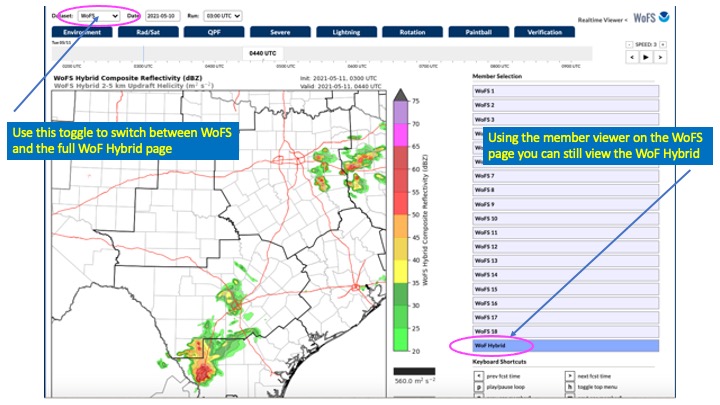
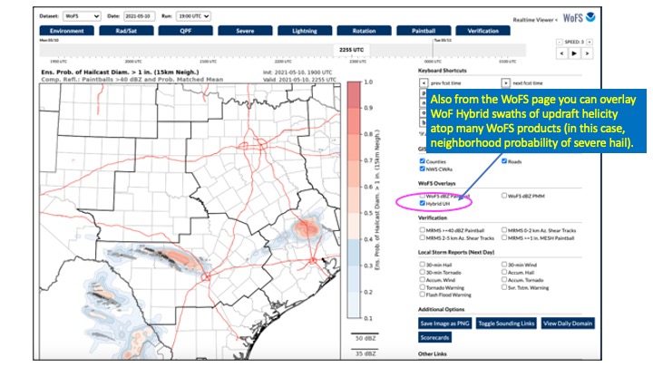
In parallel with the baseline WoFS, there is an additional deterministic forecast member, called WoF Hybrid, which is of higher resolution and is built from a different modeling approach. WoF Hybrid is an efficient, weather-adaptive, hybrid three-dimensional variational and Ensemble Kalman Filter analysis and forecast system. The system incorporates flow-dependent background error covariances estimated from the ensemble forecasts of the baseline WoFS, but provides a 1.5km deterministic analysis and forecast component that can be regarded as a complement to the baseline WoFS. One can think of this as mirroring the way that other coupled model systems attempt to provide one high-resolution, skillful, control forecast member to complement the associated ensemble (e.g., GFS and GEFS). Keep in mind that WoF Hybrid is produced in a different manner than the baseline WoF System, and its output is not incorporated into probabilistic fields from the baseline system. Images below illustrate how to access output from WoF Hybrid on the WoFS web viewer.
Future configurations:
The WoFS effort has enjoyed a period of success using a stable configuration from 2018-2021, but modeling within NOAA continues to evolve. To remain consistent with the Unified Forecast System and associated changes taking place at NSSL’s partner laboratory, GSL, we will undergo a period of exploratory research to create a new WoFS that uses the Finite-Volume Cubed-Sphere (FV3) dynamic core and uses ICs/BCs from the new Rapid Refresh Forecast System (RRFS). The switch to new ICs/BCs will take place in 2022, and it is hoped that a test version using FV3 will also be available.
Workflow diagrams for WoFS:
Below is a flowchart of the workflow for a) WoFS and b) WoF Hybrid. The 36-member WoFS and its companion model, WoF Hybrid, are continuously cycled every 15 minutes. Forecasts from both systems, launched at the top of each hour, are projected 6-h, and forecasts from WoFS, launched at the bottom of each hour, are projected 3-h. All WoFS forecasts are derived from 18 ensemble members. HRRRE members provide boundary conditions for WoFS, and the HRRRE control member provides boundary conditions for WoF Hybrid. HRRRE also provides initial background fields for both systems.
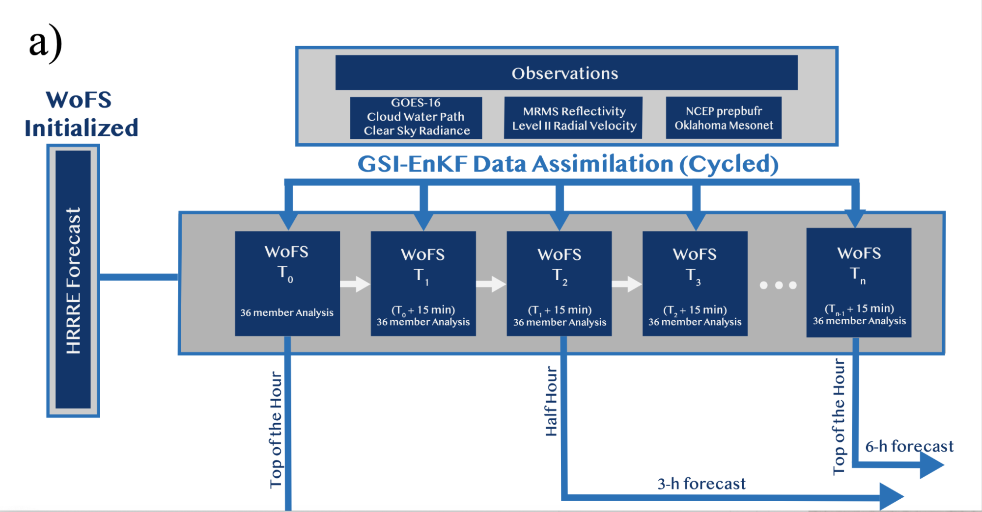
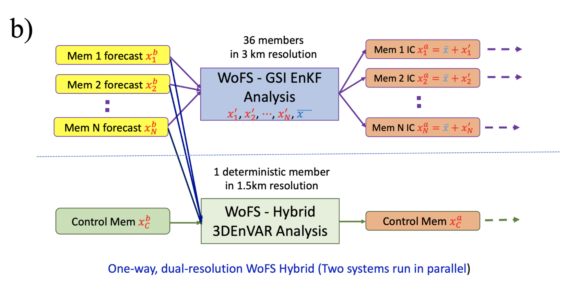
Table comparing WoFS, WoF Hybrid, and HRRRE in 2021:
| HRRRE | WoFS | WoF Hybrid | |
|---|---|---|---|
| Model Version | WRF-ARW v3.9+ | WRF-ARW v3.9+ | WRF-ARW v3.9+ |
| Grid Dimensions | 1800 x 1060 x 50 | 300 x 300 x 50 | 600 x 600 x 50 |
| Grid Resolution | 3 km | 3 km | 1.5 km |
| EnKF cycling | 36-mem. w/ GSI-EnKF every 1 hr | 36-mem. w/ GSI-EnKF every 15 min | One deterministic DA cy*cle every 15 min |
| Observations |
|
|
|
| Radiation LW/SW | RRTMG/RRTMG | Dudhia/RRTM, RRTMG/RRTMG | RRTMG/RRTMG |
| Microphysics | Thompson (aerosol aware) | NSSL double-moment | NSSL double-moment |
| PBL | MYNN | YSU, MYJ, or MYNN | MYJ |
| LSM | RUC (Smirnova) | RUC (Smirnova) | RUC (Smirnova) |
The table compares configuration between the HRRRE and WoFS ensembles and the WoF Hybrid single member, deterministic model. There are many similarities, and HRRRE forecasts are used as initial conditions and lateral boundary conditions for WoFS. WoF Hybrid, in turn, derives its initial conditions from WoFS. Note that WoFS and WoF Hybrid assimilate a greater variety of observational data than HRRRE, including WSR-88D radial velocity from MRMS and GOES-16 satellite data, and use NSSL double moment microphysics, which can generate more accurate model depictions of convection by better representing hydrometeor distributions.
References:
Anderson, Jeffrey L. (2008). “Spatially and temporally varying adaptive covariance inflation for ensemble filters.” Tellus A 61, no. 1 (December): 72-83. https://doi.org/10.1111/j.1600-0870.2008.00361.x.
Benjamin, Stanley G., Sephen S. Weygandt, John M. Brown, Ming Hu, Curtis R. Alexander, Tatiana G. Smirnova, Joseph B. Olson, et al. (2016). “A North American Hourly Assimilation and Model Forecast Cycle: The Rapid Refresh.” Mon. Wea. Rev., 144, no. 4 (April): 1669–1694. https://doi.org/10.1175/MWR-D-15-0242.1.
Dawson II, Daniel T., Louis J. Wicker, Edward R. Mansell, and Robin L. Tanamachi. (2012). “Impact of the Environmental Low-Level Wind Profile on Ensemble Forecasts of the 4 May (2007) Greensburg, Kansas, Tornadic Storm and Associated Mesocyclones.” Mon. Wea. Rev., 140, no. 2 (February): 696–716. https://doi.org/10.1175/MWR-D-11-00008.1.
Dawson II, Daniel T., Edward R. Mansell, Youngsun Jung, Louis J. Wicker, Matthew R. Kumjian, and Ming Xue. (2014). “Low-Level ZDR Signatures in Supercell Forward Flanks: The Role of Size Sorting and Melting of Hail.” J. Atmos. Sci., 71, no. 1 (January): 276-299. https://doi.org/10.1175/JAS-D-13-0118.1.
Dowell, David C., and Louis J. Wicker. (2009). “Additive Noise for Storm-Scale Ensemble Data Assimilation.” J. Atmos. Oceanic Technol., 26, no. 5 (May): 911–927. https://doi.org/10.1175/2008JTECHA1156.1.
Dowell, David C., Louis J. Wicker, and Chris Synder. (2011). “Ensemble Kalman Filter Assimilation of Radar Observations of the 8 May (2003) Oklahoma City Supercell: Influences of Reflectivity Observations on Storm-Scale Analyses.” Mon. Wea. Rev., 131, no. 1 (January): 272–294. https://doi.org/10.1175/2010MWR3438.1.
Dowell, David C. (2016). Development of a High-Resolution Rapid Refresh Ensemble (HRRRE) for severe weather forecasting. 28th Conference on Severe Local Storms ed. Portland, Oregon: American Meteorological Society.
Dowell, David C., Curtis R. Alexander, Eric P. James, S. S. Weygandt, Stanley G. Benjamin, G. S. Manikin, B. T. Blake, et al. (2021). “The High-Resolution Rapid Refresh: An hourly updating convection-permitting forecast model. Part I: Motivation and system description.” Wea. Forecasting, IN REVIEW.
Gao, Jidong, Ming Xue, Alan Shapiro, and Kelvin K. Droegemeier. (1999). “A Variational Method for the Analysis of Three-Dimensional Wind Fields from Two Doppler Radars.” Mon. Wea. Rev., 127 (September): 2128-2142.
Gao, Jidong, Ming Xue, and Kelvin K. Droegemeier. (2004). “A three-dimensional variational DA method with recursive filter for single-Doppler radar.” J. Atmos. Oceanic Technol., 21:457-469.
Gao, Jidong, and David J. Stensrud. (2012). “Assimilation of Reflectivity Data in a Convective-Scale, Cycled 3DVAR Framework with Hydrometeor Classification.” J. Atmos. Sci., 69, no. 3 (March): 1054-1065. https://doi.org/10.1175/JAS-D-11-0162.1.
Gao, Jidong, Travis M. Smith, David J. Stensrud, Chenghao Fu, Kristin Calhoun, Kevin L. Manross, Jeffrey Brogden, et al. (2013). “A Real-Time Weather-Adaptive 3DVAR Analysis System for Severe Weather Detections and Warnings.” Wea. Forecasting, 28, no. 3 (June): 727-745. https://doi.org/10.1175/WAF-D-12-00093.1.
Gao, Jidong, and David J. Stensrud. (2014). “Some Observing System Simulation Experiments with a Hybrid 3DEnVAR System for Storm-Scale Radar Data Assimilation.” Mon. Wea. Rev., 142, no. 9 (September): 3326-3346. https://doi.org/10.1175/MWR-D-14-00025.1.
Gaspari, Gregory, and Stephen E. Cohn. (1999). “Construction of correlation functions in two and three dimensions.” Q. J. R. Meteorol. Soc., 125, no. 554 (January): 725-757. https://doi.org/10.1002/qj.49712555417.
Johnson, A., X. Wang, J. R. Carley, L. J. Wicker, and C. Karstens. ( 2015). A comparison of multiscale GSI-based EnKF and 3DVar data assimilation using radar and conventional observations for midlatitude convective-scale precipitation forecasts. Mon. Wea. Rev., 143, 3087–3108, https://doi.org/10.1175/MWR-D-14-00345.1.
Jones, Thomas A., and David J. Stensrud. (2012). “Assimilating AIRS Temperature and Mixing Ratio Profiles Using an Ensemble Kalman Filter Approach for Convective-Scale Forecasts.” Wea. Forecasting, 27, no. 3 (June): 541-564. https://doi.org/10.1175/WAF-D-11-00090.1.
Jones, Thomas A., David J. Stensrud, Patrick Minnis, and Rabindra Palikonda. (2013)a. “Evaluation of a Forward Operator to Assimilate Cloud Water Path into WRF-DART.” Mon. Wea. Rev., 141, no. 7 (July): 2272–2289. https://doi.org/10.1175/MWR-D-12-00238.1.
Jones, Thomas A., Jason A. Otkin, David J. Stensrud, and Kent Knopfmeier. (2013)b. “Assimilation of Satellite Infrared Radiances and Doppler Radar Observations during a Cool Season Observing System Simulation Experiment.” Mon. Wea. Rev., 141, no. 10 (October): 3273-3299. https://doi.org/10.1175/MWR-D-12-00267.1.
Jones, Thomas A., Jason A. Otkin, David J. Stensrud, and Kent Knopfmeier. (2014). “Forecast Evaluation of an Observing System Simulation Experiment Assimilating Both Radar and Satellite Data.” Mon. Wea. Rev., 142, no. 1 (January): 107-124. https://doi.org/10.1175/MWR-D-13-00151.1.
Jones, Thomas A., and David J. Stensrud. (2015). “Assimilating Cloud Water Path as a Function of Model Cloud Microphysics in an Idealized Simulation.” Mon. Wea. Rev., 143, no. 6 (June): 2052–2081. https://doi.org/10.1175/MWR-D-14-00266.1.
Jones, Thomas A., David J. Stensrud, Louis Wicker, Patrick Minnis, and Rabindra Palikonda. (2015). “Simultaneous Radar and Satellite Data Storm-Scale Assimilation Using an Ensemble Kalman Filter Approach for 24 May (2011).” Mon. Wea. Rev., 143, no. 1 (January): 165-194. https://doi.org/10.1175/MWR-D-14-00180.1.
Jones, Thomas A., Kent Knopfmeier, Dustan Wheatley, Gerald Creager, Patrick Minnis, and Rabindra Palikonda. (2016). “Storm-Scale Data Assimilation and Ensemble Forecasting with the NSSL Experimental Warn-on-Forecast System. Part II: Combined Radar and Satellite Data Experiments.” Mon. Wea. Rev., 31, no. 1 (February): 297-327. https://doi.org/10.1175/WAF-D-15-0107.1.
Jones, Thomas A., Xuguang Wang, Patrick Skinner, Aaron Johnson, and Yongming Wang. (2018)a. “Assimilation of GOES-13 Imager Clear-Sky Water Vapor (6.5 μm) Radiances into a Warn-on-Forecast System.” Mon. Wea. Rev., 146, no. 4 (April): 1077-1107. https://doi.org/10.1175/MWR-D-17-0280.1.
Jones, Thomas A., Patrick Skinner, Kent Knopfmeier, Edward Mansell, Patrick Minnis, Rabindra Palikonda, and William Smith Jr. (2018)b. “Comparison of Cloud Microphysics Schemes in a Warn-on-Forecast System Using Synthetic Satellite Objects.” Wea. Forecasting, 33, no. 6 (December): 1681–1708. https://doi.org/10.1175/WAF-D-18-0112.1.
Jones, Thomas A., Patrick Skinner, Nusrat Yussouf, Kent Knopfmeier, Anthony Reinhart, and David Dowell. (2019). “Forecasting High-Impact Weather in Landfalling Tropical Cyclones Using a Warn-on-Forecast System.” Bull. Amer. Meteor. Soc., 100, no. 8 (August): 1405–1417. https://doi.org/10.1175/BAMS-D-18-0203.1.
Jones, Thomas A., Patrick Skinner, Nusrat Yussouf, Kent Knopfmeier, Anthony Reinhart, Xuguang Wang, Kristopher Bedka, William Smith Jr., and Rabindra Palikonda. (2020). “Assimilation of GOES-16 Radiances and Retrievals into the Warn-on-Forecast System.” Mon. Wea. Rev., 148, no. 5 (April): 1829–1859. https://doi.org/10.1175/MWR-D-19-0379.1.
Lawson, John R., John S. Kain, Nusrat Yussouf, David C. Dowell, Dustan M. Wheatley, Kent H. Knopfmeier, and Thomas A. Jones. (2018). “Advancing from Convection-Allowing NWP to Warn-on-Forecast: Evidence of Progress.” Wea. Forecasting, 33, no. 2 (April): 599–607. https://doi.org/10.1175/WAF-D-17-0145.1.
Lorenc, Andrew C. (2003). “The potential of the ensemble Kalman Filter for NWP—a comparison with 4D-Var.” Q. J. R. Meteorol. Soc., 129 (October): 3183-3203. https://doi.org/10.1256/qj.02.132.
Mallick, Swapan, and Thomas A. Jones. (2020). “Assimilation of GOES-16 satellite derived winds into the warn-on-forecast system.” Atmospheric Research 245 (November): 105-131. https://doi.org/10.1016/j.atmosres.2020.105131.
Mansell, Edward R., Conrad L. Ziegler, and Eric C. Bruning. (2010). “Simulated Electrification of a Small Thunderstorm with Two-Moment Bulk Microphysics.” J. Atmos. Sci., 67, no. 1 (January): 171-194. https://doi.org/10.1175/2009JAS2965.1.
Skamarock, William C. (2008). A description of the Advanced Research WRF version 3, NCAR Technical Note. N.p.: NCAR. Note NCAR/TN-4751STR.
Skinner, Patrick S., Dustan M. Wheatley, Kent H. Knopfmeier, Anthony E. Reinhart, Jessica J. Choate, Thomas A. Jones, Gerald J. Creager, et al. (2018). “Object-Based Verification of a Prototype Warn-on-Forecast System.” Wea. Forecasting, 33, no. 5 (October): 1225-1250. https://doi.org/10.1175/WAF-D-18-0020.1.
Smith, Travis M., Valliappa Lakshmanan, Gregory J. Stumpf, Kiel L. Ortega, Kurt Hondl, Karen Cooper, Kristin M. Calhoun, et al. (2016). “Multi-Radar Multi-Sensor (MRMS) Severe Weather and Aviation Products: Initial Operating Capabilities.” Bull. Amer. Meteor. Soc., 97, no. 9 (September): 1617–1630. https://doi.org/10.1175/BAMS-D-14-00173.1.
Stensrud, David J., Jian-Wen Bao, and Thomas T. Warner. (2000). “Using Initial Condition and Model Physics Perturbations in Short-Range Ensemble Simulations of Mesoscale Convective Systems.” Mon. Wea. Rev., 128, no. 7 (July): 2077-2107. https://doi.org/10.1175/1520-0493(2000)128<2077:UICAMP>2.0.CO;2.
Stratman, Derek R., Nusrat Yussouf, Youngsun Jung, Timothy A. Supinie, Ming Xue, Patrick S. Skinner, and Bryan J. Putnam. (2020). “Optimal Temporal Frequency of NSSL Phased Array Radar Observations for an Experimental Warn-on-Forecast System.” Wea. Forecasting, 35, no. 1 (February): 193-214. https://doi.org/10.1175/WAF-D-19-0165.1.
Stensrud, David J., Jian-Wen Bao, and Thomas T. Warner. (2000). “Using Initial Condition and Model Physics Perturbations in Short-Range Ensemble Simulations of Mesoscale Convective Systems.” Mon. Wea. Rev., 128, no. 7 (July): 2077-2107. https://doi.org/10.1175/1520-0493(2000)128<2077:UICAMP>2.0.CO;2.
Stensrud, David J., and Jidong Gao. (2010). “Importance of Horizontally Inhomogeneous Environmental Initial Conditions to Ensemble Storm-Scale Radar Data Assimilation and Very Short-Range Forecasts.” Mon. Wea. Rev., 138, no. 4 (April): 1250-1272. https://doi.org/10.1175/2009MWR3027.1.
Wang, Yongming, and Xuguang Wang. (2017). “Direct Assimilation of Radar Reflectivity without Tangent Linear and Adjoint of the Nonlinear Observation Operator in the GSI-Based EnVar System: Methodology and Experiment with the 8 May (2003) Oklahoma City Tornadic Supercell.” Mon. Wea. Rev., 145, no. 4 (April): 1447-1471. https://doi.org/10.1175/MWR-D-16-0231.1.
Wheatley, Dustan M., Kent H. Knopfmeier, Thomas A. Jones, and Gerald J. Creager. (2015). “Storm-Scale Data Assimilation and Ensemble Forecasting with the NSSL Experimental Warn-on-Forecast System. Part I: Radar Data Experiments.” Wea. Forecasting, 30, no. 6 (December): 1795–1817. https://doi.org/10.1175/WAF-D-15-0043.1.
Yussouf, Nusrat, and David J. Stensrud. (2012). “Comparison of Single-Parameter and Multiparameter Ensembles for Assimilation of Radar Observations Using the Ensemble Kalman Filter.” Mon. Wea. Rev., 140, no. 2 (February): 562-586. https://doi.org/10.1175/MWR-D-10-05074.1.
Yussouf, Nusrat, Edward R. Mansell, Louis J. Wicker, Dustan M. Wheatley, and David J. Stensrud. (2013). “The Ensemble Kalman Filter Analyses and Forecasts of the 8 May (2003) Oklahoma City Tornadic Supercell Storm Using Single- and Double-Moment Microphysics Schemes.” Mon. Wea. Rev., 141, no. 10 (October): 3388–3412. https://doi.org/10.1175/MWR-D-12-00237.1.
Yussouf, Nusrat, David C. Dowell, Louis J. Wicker, Kent H. Knopfmeier, and Dustan M. Wheatley. (2015). “Storm-Scale Data Assimilation and Ensemble Forecasts for the 27 April 2011 Severe Weather Outbreak in Alabama.” Mon. Wea. Rev., 143, no. 8 (August): 3044–3066. https://doi.org/10.1175/MWR-D-14-00268.1.
Yussouf, Nusrat, John S. Kain, and Adam J. Clark. (2016). “Short-Term Probabilistic Forecasts of the 31 May 2013 Oklahoma Tornado and Flash Flood Event Using a Continuous-Update-Cycle Storm-Scale Ensemble System.” Wea. Forecasting, 31, no. 3 (June): 957-983. https://doi.org/10.1175/WAF-D-15-0160.1.
Yussouf, Nusrat, and Kent H. Knopfmeier. (2019). “Application of the Warn-on-Forecast system for flash-flood-producing heavy convective rainfall events.” Q. J. R. Meteorol. Soc., 145, no. 723 (May): 2385-2403. https://doi.org/10.1002/qj.3568.
Yussouf, Nusrat, Thomas A. Jones, and Patrick S. Skinner. (2020)a. “Probabilistic high-impact rainfall forecasts from landfalling tropical cyclones using Warn-on-Forecast system.” Q. J. R. Meteorol. Soc., 146, no. 730 (March): 2050-2065. https://doi.org/10.1002/qj.3779.